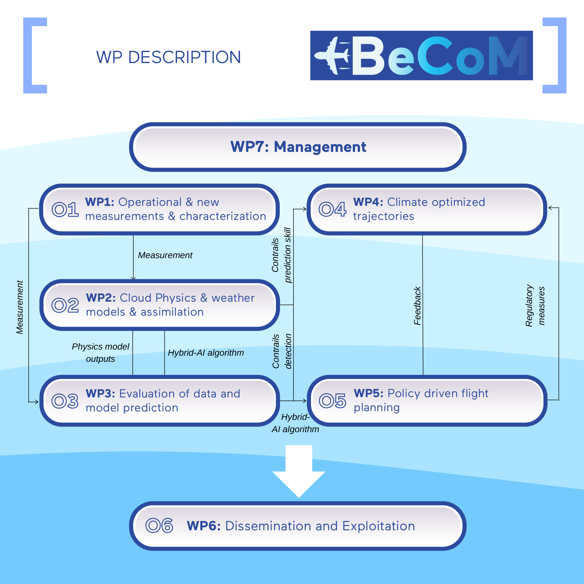
Work Package 2
Cloud Physics & Weather Models & Assimilation
Participant : DWD, DLR, Thales, TUD
WP leader : DWD
Start month : 01 – End month : 46
Main contact: Alexander.Cress@dwd.de
Objectives:
Develop the assimilation of cloud and contrail observations from satellites based on the MFASIS operator, which recently was included in the EUMETSAT RTTOV package for operational NWP.
Explore the use of additional humidity observations and airplane borne camera images for assimilation within NWP models, in particular including AI based identification and characterization algorithms as a part of the observation processing and forward observation operator.
Design a new ice cloud physics formulation with intermediate complexity for use in numerical prediction.
Improve the forecasting of contrails based on improved parametrization and better estimation of the atmospheric state at and around flight level.
Description of work:
T2.1: Assimilation of Cloud Observations by Satellite Borne Reflectance Measurements
This task intends to make significant progress in using satellite data in the visible range in Numerical Weather Prediction. The MFASIS operator is a new and fast operator simulating satellite-borne reflectance measurements, and it is available in the EUMETSAT operational RTTOV code, developed by a partnership of LMU Munich with DWD. The goal is to explore the use of measurements of high clouds and contrails within the operational Ensemble-Variational scheme of DWD to improve the representation of humidity and the prediction of contrails. This includes:
- Integrating the tangent-linear version of MFASIS into the DWD data assimilation system
- Developing and integrating proper identification and characterization algorithms (based on WP3 input)
- Executing experiments on data assimilation and forecasting.
T2.2: Explore the Use of Airplane Borne Camera Images for Improving Contrail Forecasting
The use of direct camera images in high-resolution NWP has been recently successful for the German ICON-D2 convective-scale operational forecasting system. This task aims to explore the use of camera images in the framework of the global ICON model with its ensemble-variational data assimilation system by:
- Exploring the combination of AI algorithms with classical forward operators to assimilate contrail measurements and cloud images by airborne camera images into the ICON model.
- Developing and integrating appropriate identification and characterization algorithms of contrail and cloud observations from images (based on WP3 input)
- Integrating the forward operators into the data assimilation and forecasting system
- Identifying appropriate observation error and error distributions
- Extensively testing the sensitivity and response of the system on the new observations.
T2.3: Concept of ice cloud microphysics modules with intermediate complexity for use in numerical weather prediction
This task intends to develop a new concept allowing a better representation of cloud evolution in the supersaturated environment.
- The saturation adjustment will be abandoned, and cirrus clouds will not form before a critical supersaturation is reached. The growth rate of the ice mass will be proportional to its thermodynamic force, i.e., the degree of supersaturation. Accordingly, a cloud will not vanish entirely as soon as there is subsaturation.
- The newly developed concept will be implemented in a box-model version and finally tested in a 3D environment